Geelong's Water Supply
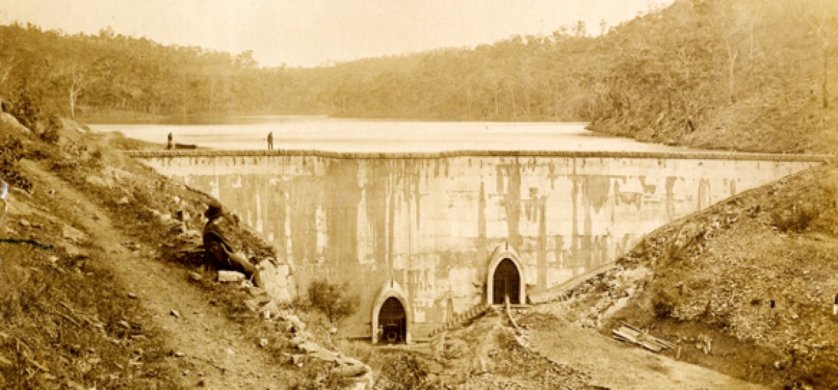
The Lower Stony Creek reservoir pictured below was built between February 1873 and June 1874 to supply water to the growing city of Geelong. It has the distinction of not only being the first concrete dam built in Australia, but only the third such dam in the world. Its successful completion gave Geelong its first reliable water supply, which was essential for its industrial and commercial growth, for public health and protection from fire.
On 3 February 2011 we submitted a comprehensive application to Heritage Victoria for the listing of the Lower Stony Creek dam wall. Six years and followups later, they have finally agreed that the dam wall should be listed in the Victorian Heritage Register. There are still some formalities/ bureaucratic processes to go through, but this is a significant listing for this solid reminder of our recent cultural heritage.
In the beginning, the Barwon River was the main source of water for the infant settlement of Geelong. Pumps installed on its banks raised water for the carriers, some of whom did not bother with the pumps and dipped buckets into the river to fill their casks, stirring up the mud. As well as being muddy, the Barwon's waters were quite brackish due to tidal influence. Settlers had to go as far as Buckley Falls for pure water, or even relied on casks shipped from Melbourne.
The brackish condition was partly overcome in 1841 when a stone weir was built across the stream by convict labour, under the direction of Geelong's first police magistrate, Captain Foster Fyans. Breakwater became the common name for the weir and eventually the suburb nearby.
An energetic pioneer shopkeeper, William Gray, took advantage of the breakwater to install steam driven pumps on the river bank. Water was pumped to the town through an iron pipeline, two and a half kilometres long. On April first 1850 the first delivery of water was made from a fountain in Market Square. The fountain proved inadequate and was replaced by a large tank, 27 metres in circumference and supported by stone pillars. It was designed to fill eight water carts in two minutes. The Town Council and Mr Gray continually argued over the rent for the site of the tank. The Council claimed the continuous stream of carts churned up the roads leading to Market Square and said Gray's charge of two shillings a cartload was exorbitant. But for many years Gray's crude system, which continually broke down, was Geelong's only water supply.
The Town Council was the leader in efforts to procure a better water system. Continuous complaints to the Victorian Parliament about the inadequacy of the supply finally led to Parliament voting 200,000 pounds in 1856 to supply the town with water. But in 1858, one thousand Geelong residents, outraged to discover the money had been spent on Melbourne's Yan Yean Reservoir, held a public meeting. But Geelong was left to rely on Gray's tank or supplies carried by water cart from the Barwon. Many citizens constructed underground brick tanks to store water collected from the roofs of their homes.
Year after year the battle for a water supply continued. A serious fire in Geelong finally brought home the importance of a reliable supply. The well known landmark, Singapore Terrace, was burnt to the ground despite 76 loads of water dragged from Gray's waterworks. Even Melbourne-loving politicians realized how badly Geelong was equipped to fight a big fire.
At last the Government gave in and, in May 1866, began to build a dam across Stony Creek in the Brisbane Ranges 40 kilometres north of Geelong. But delays and problems with the work meant that it was not until April 1873 that the first tap was turned on at the Geelong Hospital.
Geelong's first permanent water source, the Lower Stony Creek reservoir, in 1873
Geelong's water problems did not stop there. During the 1880s, there were many complaints. On hot days Newtown was completely without water. In the 1898-9 drought, the Government tried to install pumps on the Barwon River but there was an indignant outcry at a public meeting at the proposal to pump the contaminated Barwon water into the system. Rain in March averted the necessity.
The Government decided to construct a diversion weir to take water from the Easter Moorabool to Stony Creek. Its engineers recommended a channel carrying 23 megalitres a day. Geelong engineers said 46 megalitres a day were needed. Geelong wanted the channel lined. The Government saved money by leaving it unlined.
Not surprisingly, a movement for the purchase of the waterworks gained strength under the leadership of the mayor of Geelong, Cr Thomas Bostock. The Government finally agreed to sell the waterworks for 265,000 pounds. After 42 years of government control, the Geelong Municipal Waterworks Trust was formed in 1907 with power to supply water to all places within eight kilometres of the Geelong Post Office and sixteen kilometres either side of the main Stony Creek pipeline. Its first meeting was held on January 25th 1908. Two years later the Trust assumed responsibility for sewering the city and the name was changed to the Geelong Waterworks and Sewerage Trust.
When the Trust took over in 1908, the waterworks consisted of the Stony Creek Reservoir, a diversion weir from the East Moorabool to the reservoir, an aqueduct to the pipe head basin at Anakie and a pipeline from there to service basins at Lovely Banks and Montpellier. Since then, water storage capacity and services have been increased dramatically.
The Korweinguboora Reservoir was built on the East Moorabool and two more reservoirs were built at Stony Creek.
Geelong also agreed to buy water in bulk to supplement its Moorabool supply from the 1929 Government built weirs on both branches of the Upper Barwon River. These weirs were connected by a tunnel and the water flowed by channel to the Wurdee Boluc Reservoir and then to Pettavel service basin. This Otway water was piped to Geelong and the Bellarine towns.
A new storage, Bostock Reservoir on the East Moorabool, was added in 1954, but Geelong needed further supplies.
The solution came when the Government sold the Barwon headworks to the Trust and construction began on the west Barwon Dam. Completion of this largest storage in the Geelong system in 1965 allowed the Trust to reverse the process by selling bulk water to State Rivers and Water to supply the Bellarine Peninsula and coastal towns as far as Anglesea. Supplies were boosted again when the West Moorabool Water Board constructed the Bungal dam near Lal Lal in 1972. This reservoir's capacity equalled the capacity of all Geelong's storages at that time. Its water is shared between Ballarat and Geelong with Geelong being entitled to a third of the supply.
Barwon Downs ground water was added into the supply in 1983 following the 1982/83 drought (the worst on record in Geelong) when the West Barwon Dam, Bostock and Koreinguboora Reservoirs all ran dry.
Description of The Eastern Moorabool System
The supply from the Eastern Moorabool River is the oldest of Geelong's water supply systems and provides approximately one fifth of the city's requirements.
The catchment area of this system is approximately 100 square kilometres in extent and is situated in the great Dividing Range on the headwaters of the Eastern Moorabool River. The average annual rainfall in the area is 760 mm and is confined mainly to the winter months. The river generally flows for about seven months each year and is dry for five months. The greatest part of the run-off from the area occurs during the floods which follow the periods of heaviest rainfall and these floods are controlled primarily by the Korweinguboora Reservoir.
All this supply, at some stage, flows through the Brisbane Ranges National Park. Prior to 1999, water from the Lower Stony Reservoir was directed by pipeline through Anakie Gorge and on to Geelong with the rest being directed to Anakie Basin via channels and aqueduct. Since then Eastern Moorabool water is piped through a new pipeline which runs from the Durdidwarrah storages across the Park (under Durdidwarrah Rd and Hut Track) and on to Geelong. The aqueduct and Anakie pipeline and Basin will be surplus to Barwon Water's requirements.
Koreinguboora Reservoir

This is an earthen dam built across the Eastern Moorabool River and is situated 80 km north of Geelong and 20 km east of Ballarat. The holding capacity of the reservoir is 2,100 ML, which is relatively small and approximately only one-third of the average run-off from the catchment. The purpose of the dam is to control floods and to allow water to be drawn off from the catchment area in quantities which can be controlled. In other words, water enters the reservoir at rates which vary and are dependent on the rainfall and in quantities which may fill the reservoir in a few days. It leaves the reservoir, for transmission to the Trust's main reservoirs, at a regular rate throughout the winter months. In this way, the reservoir is sometimes filled and emptied several times during one year.
Water from the reservoir, in the first stage of its transit to the main storages, is allowed to flow down the Eastern Moorabool River for a distance of 6.4 km to the Bolwarrah Weir.
Bolwarrah Weir
Bostock Reservoir
This is a storage reservoir formed by an earth and rockfill dam constructed across the Eastern Moorabool just below its junction with Paddock Creek. The holding capacity of the reservoir is 7,640 megalitres. The reservoir is connected to the remainder of the Eastern Moorabool system by an open channel 9 km in length.
Ballan Channel
This channel has been constructed across country and runs generally in a southerly direction for a distance of 37 km, passing through the Parishes of Moorabool West, Gorong, Yaloak, Bungeeltap, Ballark and Beremboke. The water from the Eastern Moorabool River - after being raised in elevation by the Bolwarrah Weir - enters this channel and flows out of the catchment area in which it was collected across country and into the main storages which are situated in the catchment area of the Little River in the Brisbane Ranges.
The Ballan Channel is capable of transmitting 65 megalitres of water per day. The water transmitted by the channels is discharged into the storages at Stony Creek.
Stony Creek
The main storages on the Eastern Moorabool system are at Stony Creek and have a total capacity of ,761 megalitres. They receive and store water from the Eastern Moorabool catchment, as described above, as well as the very limited run-off from that part of the Little River catchment area in which they are situated. This catchment extends to 13 square kilometres in area and has an average rainfall of 710 mm. There are four reservoirs at Stony Creek: 3 at Upper Stony Creek (Durdidwarrah), and one at Lower Stony Creek (Concrete Dam).
Upper Stony Creek No. 1 Reservoir was formed in 1870 by constructing an earthen embankment across Stony Creek. This embankment impounds 3,443 megalitres when full. Reservoirs Nos. 2 and 3 were formed in the same area by construction of banks around natural depressions. They contain 2,345 and 3,706 megalitres respectively when full.
Lower Stony Creek Reservoir was constructed in 1872 and, when full, contains 267 megalitres.
In order to reach the city, water from Upper Stony Creek runs through an open brick-lined aqueduct, 10.5 km long, to the Anakie Pipe Head Basin. There it is screened and piped to Geelong, a distance of 24 km, through two mains, one 350 mm and the other 375 mm in diameter, which discharge into the Service Basins at Lovely Banks.
The water from Lower Stony Creek Reservoir is also taken to Geelong through the same mains, but it does not run down the race to Anakie Pipe Head Basin. It is taken by a 375 mm main through Anakie Gorge and joins the outlet pipes from Anakie Pipe Head Basin downstream from the Basin.